
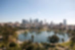
Welcome to Our Neighborhood
pick your future community
Scroll Down

eagle rock
The lovely city of Eagle Rock is bordered by the city of Glendale on the north and west, Highland Park on the southeast, Glassell Park on the southwest and the cities of Pasadena and South Pasadena on the east. The major thoroughfares include Eagle Rock Boulevard and Colorado Boulevard, with Figueroa Street along the eastern boundary. The Glendale and Ventura freeways run along the district’s western and northern edges.
Eagle Rock was recently noted as one of the top ten “hottest” housing markets in the nation!
Interesting tidbits about Eagle Rock:
-
The neighborhood is inhabited by a wide variety of ethnic and socioeconomic groups and the creative class. Over the past decade the Eagle Rock and neighboring Highland Park have been experiencing gentrification, and has become a favored housing area. Eagle Rock has been home many famous motion picture actors and actresses, along with writers and others involved in the industry. Young urban professionals, and those with families are drawn to the “small town” feel that Eagle Rock is noted for.
-
Eagle Rock has always been a popular filming location for many major motion picture studios. Especially with it’s close proximity to Hollywood and the studios. Some notable films have had scenes shot around this community, including Top Gun, Hunt for Red October, and a second-season episode of The O.C. Star Trek III was partially filmed on the campus of Occidental College. This campus also served as “California University” in the 1990s television series, Beverly Hills, 90210. Quentin Tarantino filmed parts of Reservoir Dogs here and in neighboring Highland Park. Other movies filmed almost entirely in Eagle Rock include; all of the exterior scenes of The Incredible Shrinking Woman starring Lily Tomlin, Record City with Ed Begley, Jr. was filmed in its entirety in a defunct auto paint shop, and The Unwed Father starring Timothy Bottoms had all of its exterior location shots filmed on the Eagle Rock High School campus. More recently, Avril Lavigne’s music video “Complicated” was mostly shot in the Eagle Rock Mall as well as some scenes from the popular TV show, Glee. One scene from 500 Days of Summer was also shot in one of the streets intersecting Hill Drive. Sons of Anarchy, a currently popular show, has been sighted filming scenes at the Italian Bakery, located on Colorado Boulevard.
-
Some of the architecture of Eagle Rock has been featured as well; a house on the 5200 block of Shearin Avenue was used during the 1984 filming of Teen Wolf, starring Michael J. Fox, and a house on the 4900 block of College View Avenue was used during the 1975 filming of The Day of the Locust, starring Donald Sutherland.
-
Ben Affleck, a former Occidental College student, lived on Hill Drive with then-roommate and co-writer Matt Damon while they wrote the script for Good Will Hunting, which would go on to win them a Best Original Screenplay Academy Award.
-
Eagle Rock is the site of Occidental College, more recently brought into the public eye when it was revealed that our current president attended school there. Interestingly, Occidental College, was first established in Boyle Heights in 1887 but a fire destroyed its original site in 1896; from there the college moved to Highland Park and then to Eagle Rock in 1914. The campus was designed by architect Myron Hunt.
echo park
Full of life with an interesting and varied cultural history, Echo Park is a wonderful, diverse area of Los Angeles.
Sharing borders with Elysian Park and our famous Dodger’s Stadium, as well as it’s close proximity to Chinatown and Olvera Street, Echo Park’s history is rich with artistic and multicultural diversity. Many people of different cultures have called this area home.
Interesting facts about Echo Park include:
-
Echo Park began to be a popular place of residence in and around the 1890s, when the Los Angeles street car line was extended. By this time, City of Los Angeles had begun to turn the land immediately surrounding the lake into a park, and individuals started to establish businesses and residences along Sunset and around the lake.
-
In Northern Echo Park, in an area once known as Edendale, most ofthe silent films made during theearly years of film, were made in one of the studios housed on what is now Glendale Boulevard.
-
As well as being culturally diverse, Echo Park has been home to a wide variety of social strata. Historically, and even to this day, it is home to to wealthy business people, families, artists and free-thinkers.
Along with its close proximity to Downtown Los Angeles, Echo Park has several historic “claim to fame”. Among these are its very popular lake and more than two dozen stairways in and among the hillsides of the area. Many are public walkways and have been/are critical to residents residing in Echo Park. Echo Parks hilly topography makes these stairways very practical. One in particular to note is the Baxter Stairway: Climbing the more than 230 steps will leave you in awe or in cardiac arrest. The top of the stairs is across the street from Elysian Park and its many walking trails. Located on Baxter Street, three blocks east of Echo Park Ave. Baxter Street has been noted as one of, if not the, steepest street in Los Angeles.
Some notable residents of Echo Park include:
Jackson Browne, Musician
Leonardo DiCaprio, Actor
Glenn Frey, Musician
Eric Garcetti
Marilyn Horne, Soprano
John Huston, Film Director
Paul Landacre, Artist
Shia LaBeouf, Actor
Henry Jay Lewis, Musical Conductor
Edward Middleton Manigault, Painter
Steve McQueen, Actor, lived on Vestal Street in 1955
Art Pepper, Jazz Musician
Leo Politi, Artist and Illustrator
Jackson Pollock, Artist
Elliott Smith, Musician, Singer, Songwriter
J. D. Souther, Musician

Some historical and interesting information:
Glassell Park was originally part of Rancho San Rafael, granted in 1784 to Spanish army corporal José María Verdugo. Attorney Andrew Glassell received part of Rancho San Rafael from the lawsuit known as the Great Partition of 1871. Glassell eventually settled in the area with his family, for whom many streets, including Toland Way, Drew, Andrita and Marguarite Streets are named.
The development of Glassell Park began in the early 20th Century, as subdivisions between Verdugo and San Fernando Roads began to be sold in 1907. In 1912, the city of Los Angeles annexed most of Glassell Park, annexing the remainder in 1916. The Glassell family subdivided their land, selling off what is now Forest Lawn Memorial Park during the Great Depression. The growing neighborhood was served by a line of the Los Angeles Railway, which traveled in the median of Eagle Rock Boulevard towards Eagle Rock. Today, Glassell Park is rediscovering its history from the Verdugo era. Glassell Park also hosts the historical road of trade between the Verdugo Rancho and the fledging Pueblo of Los Angeles. This road is called Verdugo Road, which historically met up with San Fernando Road.
Today Glassell Park is home to people of many cultures and backgrounds. The neighborhood has been significantly affected by the Southern California real estate boom that began in the early 2000s. An influx of families have moved into the neighborhood, attracted by the abundance of Craftsman homes and relatively low prices. Over the past decade Glassell Park and neighboring Eagle Rock have been experiencing gentrification, as many people have moved from nearby neighborhoods such as Los Feliz and Silver Lake.

highland park
Highland Park, one of the oldest settled areas of Los Angeles, is a hilly neighborhood located along the Arroyo Seco. It is situated within what was once Rancho San Rafael of the Spanish / Mexican era. Its boundaries are roughly the Pasadena Freeway on the southeast, the city limits of Pasadena on the northeast, Oak Grove Drive on the north, and Avenue 51 on the west.
Highland Park is also one of the most scenic areas of Los Angeles, due to its architecture and location between the Mt. Washington hills, the San Rafael hills and the Monterey Hills of Los Angeles, California. It has sprawling parks, including the Arroyo Seco Park and the Ernest E. Debs Regional Park. The Southwest Museum, with one of the largest and most significant collections of Native American artifacts in the country, is located in adjacent Mt. Washington. The light rail Metro Gold Line travels from East Los Angeles Atlantic Station through Union Station to Pasadena, traversing all of Highland Park.
Once again, Highland Park is building a reputation as a mecca for artists, with trendy shops, galleries, bars and restaurants opening throughout the neighborhood. The continuation of several long-time businesses lend credibility to the neighborhood’s charming status.
Interestingly, because of the picturesque neighborhoods in and around Highland Park, many movies are filmed here. The short list:
-
Reservoir Dogs – shot largely in Highland Park
-
Cutter’s Way – starring Jeff Bridges was filmed, for the most part, on Aldama Street.
-
La Bamba – filmed at the VFW hall on Avenue 53 for dance hall scene.
-
The Lincoln Lawyer – location for the bar The York on York, starring Matthew McConaughey, William H. Macy and Marisa Tomei
-
Supernatural (tv series) – a scene in the pilot episode featured the Highland Park Theater on Figueroa Street
-
Gangster Squad – In early 2012 the entire Highland Park downtown area along Figueroa Street was redone to look like post-WWII-era Los Angeles for the film, starring Ryan Gosling and Sean Penn.
-
Tuff Turf – starring James Spader was shot in Highland Park
-
Up in Smoke starring Cheech and Chong.
-
Yes Man
-
Cyrus
-
10-8: Officers on Duty
-
Karate Kid III – scenes of Mr. Miyagi’s store were filmed at the corner of Ave 50 and Marmion Way
-
Fletch (film) – Chase scenes were filmed on Avenue 51 and York Boulevard
-
My Family (film) starring Jimmy Smits has him dancing in the street on Avenue 50 and Granada Avenue
In addition, many television and features films have used the old Los Angeles Police Department building on the 6000 block of York Boulevard.
la crescenta Montrose
The unincorporated part encompasses those parts of the Crescenta Valley and northwestern San Rafael Hills not in the cities of Glendale or La Cañada Flintridge. Only a small portion of Montrose is unincorporated, the vast majority of it lies within the City of Glendale. Both the unincorporated area and the portion of incorporated Glendale north of Montrose are collectively called La Crescenta-Montrose.

mount washington
Mount Washington is roughly located in an area defined by Division Street on the west, El Paso Drive and Avenue 50 on the northeast, Marmion Way on the southeast, and Isabel Street on the southwest. It is considered of many beautiful neighborhoods in northeast Los Angeles. Mount Washington’s hills provide mounds of green and parts of the neighborhood provide views of downtown Los Angeles, the San Gabriel mountains, tranquil canyons, hillsides, and valleys. Neighboring cities include Glassell Park, Eagle Rock, Highland Park, Montecito Heights and Cypress Park. On a clear day, many areas have a beautiful view of the Pacific Ocean.

pasadena
Pasadena is a city in Los Angeles County, California, United States. As of 2013, the estimated population of Pasadena was 139,731, making it the 183rd-largest city in the United States. Pasadena is the ninth-largest city in Los Angeles County. Pasadena was incorporated on June 19, 1886, becoming only the second city to be incorporated in what is now Los Angeles County, after Los Angeles (April 4, 1850). It is one of the primary cultural centers of the San Gabriel Valley.
The city is known for hosting the annual Rose Bowl football game and Tournament of Roses Parade. In addition, Pasadena is also home to many scientific and cultural institutions, including the California Institute of Technology (Caltech), the Jet Propulsion Laboratory, Fuller Theological Seminary, Art Center College of Design, the Pasadena Playhouse, the Norton Simon Museum of Art and the Pacific Asia Museum.

Sierra Madre
Noteworthy Facts:
-
Meaning of city name: Spanish for "Mother Range" or "Mother Mountain".
-
Sierra Madre was named an All-America City by the National Civic League in 2007.
-
Since 1910 Sierra Madre has been a frequent filming location. Sites around town have turned up in movies such as "The Great Man's Lady", "Invasion of the Body Snatchers", "Family Plot", "The Wedding Singer", "K-Pax", "The Princess Diaries", and "Kicking & Screaming".
-
The Sierra Madre Public Library is the fourth oldest city library in Los Angeles County.
-
Sierra Madre is home of the world's largest wistaria vine. It purchased by Alice Brugman in April 1894.
-
Sierra Madre possesses the only volunteer fire department in the Los Angeles Area.
-
Sierra Madre was the first city police department in Los Angeles County to have a female Police Chief.
Located in the foothills of the San Gabriel Valley, Sierra Madre is known as "Wisteria City" and its city seal is decorated with a drawing of the now widely known 500-foot vine. It is also called the "Village of the Foothills" and was an All-America City in 2007. The city is also home to the only remaining volunteer fire department in the Greater Los Angeles area and has no traffic signals within its town limits.
Downtown Sierra Madre has small restaurants and shops, featuring a historic company that produces gourmet olives, jams, and syrups, E. Waldo Ward and Son.
The town also hosts a locally famous Independence Day parade and three days of festivities each year. Residents like to call it a "Star Spangled Weekend." Concerts, food and game booths and the ubiquitous Beer booth are all a part of the firework-free weekend.
Sierra Madre is also known for its annual Wistaria Festival, which celebrates its 1-acre Chinese wisteria vine. The plant was named by the Guinness Book of World Records as the largest flowering plant and one of the seven horticultural wonders of the world. The annual festival is the one day a year the vine on private property can be viewed. The city's more than 500-foot long Wisteria Vine, was purchased in 1894 by Mrs. William (Alice) Brugman from the old Wilson nursery, in Monrovia, for seventy-five cents. Over time, the vine, with its lavender flowers, grew so large that it crushed the house. Now the vine spans two back yards in the 500 block of North Hermosa Avenue. The vine measures more than 1 acre in size and weighs 250 tons.
On January 1, 1917, Sierra Madre made its first entry in the Pasadena Tournament of Roses parade. Since 1954, the year it was founded, the Sierra Madre Rose Float Association has organized the volunteers that decorate the self made Tournament of Roses floats every year, and receives no funds from the city. In 2010, the Sierra Madre Rose Float Association and float designer Charles Meier won their fourth award in a row, the "Lathrop K. Leishman Award" for Most Beautiful Non-Commercial Float.
Sierra Madre's "JailHouse Inn" is located in the Historic City Hall, and its "suite" is actually located at the genuine old jail. There is only one cell, so it can only "incarcerate" just one or two people per night. It is about 200 square feet and is regarded as the smallest, and perhaps most unique, bed & breakfast in the United States.

silver lake
Silver Lake is a residential and commercial neighborhood in the central region of Los Angeles, California, built around a city reservoir which gives the district its name. The "Silver" in Silver Lake is not because of the water's color, but named for the local engineer who built the reservoir. It is known for its restaurants and clubs, and many notable people have made their homes there. The neighborhood has three public and four private schools.
Silver Lake is flanked on the northeast by Atwater Village and Elysian Valley, on the southeast by Echo Park, on the southwest by Westlake, on the west by East Hollywood and on the northwest by Los Feliz.[1][2][3]
Street and other boundaries are: the Los Angeles River between Glendale Boulevard and Fletcher Drive and Riverside Drive on the northeast, the Glendale Freeway on the east, Effie Street, Coronado Street, Berkeley Avenue and Fletcher Drive on the southeast, the Hollywood Freeway on the south, Hoover Street on the west and Fountain Avenue and Hyperion Avenue on the northwest.[4] The prime real estate around the lake is known by realtors as the "Moreno Highlands."
The Silver Lake neighborhood council has mapped the boundaries of its council region.

los feliz
Los Feliz is an affluent hillside neighborhood in the central region of Los Angeles, California, abutting Hollywood and encompassing part of the Santa Monica Mountains. It is noted for its expensive historic homes and celebrity inhabitants.
The neighborhood is named after its colonial Spanish-Mexican land grantee, José Vicente Feliz, and, along with present-day Griffith Park, makes up the original Rancho Los Feliz land concession.
Los Feliz encompasses several smaller but distinct areas, including the Los Feliz Hills and Los Feliz Estates (north of Los Feliz Boulevard), Laughlin Park, Los Feliz Village, Los Feliz Square, Los Feliz Knolls, and Franklin Hills.
According to the Mapping L.A. project of the Los Angeles Times, Los Feliz is part of Central Los Angeles. It is flanked on the north by Griffith Park, on the northeast by Atwater Village, on the southeast by Silver Lake, on the south by East Hollywood, and on the northwest by Hollywood and Hollywood Hills.
Its boundaries are the Griffith Park line between Fern Dell Drive and Riverside Drive on the north; the Los Angeles River on the east; Hyperion Avenue and Griffith Park Boulevard on the southeast; Fountain Avenue and Hollywood Boulevard on the south; and Western Avenue, Los Feliz Boulevard, and Fern Dell Drive on the west and northwest.

montecito heights
Montecito Heights is a small district in Northeast Los Angeles formerly known as an original East Los Angeles area of Los Angeles, California. The 2000 population is estimated at 16,768.
Montecito Heights' boundaries are roughly the Pasadena Freeway (SR 110) or the Arroyo Seco on the northwest, Pasadena Avenue on the west, Avenue 39 to the south, Huntington Drive to the southeast, and Monterey Road to the east. Neighboring districts include Monterey Hills on the northeast, El Sereno on the southeast, Lincoln Heights on the southwest, Mount Washington on the northwest, and Highland Park on the north. Owing to the rugged terrain, no major thoroughfares run through the area. The district is largely in ZIP code 90031.
Central to just about everything and known by the residents as the 'Wilderness in the City' Montecito Heights sits atop the Monterey Hills that divide the Los Angeles Basin from the San Gabriel Valley. Montecito Heights is a relatively isolated area of greenery and trendy resident home restorers. Some of the city's most spectacular views are available on the district's hills. Along with neighboring Highland Park and Pasadena, it is one of the historic centers of the Arts and Crafts movement.

Downtown LA
Downtown Los Angeles is the central business district of Los Angeles, California, as well as a diverse residential neighborhood of some 50,000 people. A 2013 study found that the district is home to over 500,000 jobs.
A heritage of the city's founding in 1781, Downtown Los Angeles today is composed of different areas ranging from a fashion district to a skid row, and it is the hub of the city's Metro rapid transit system. Banks,department stores and movie palaces at one time drew residents and visitors into the area, but the district declined economically and suffered a downturn for decades until its recent renaissance starting in the early 2000s: Old buildings are being modified for new uses, and skyscrapers have been built. Downtown Los Angeles is known for its government buildings, parks, theaters and other public places.
School Information:
-
Ramon C. Cortines School of Visual and Performing Arts, LAUSD high school
-
Downtown Business High School, LAUSD alternative
-
California Academy for Liberal Studies Early College High School, LAUSD charter
-
Alliance Dr. Olga Mohan High School, LAUSD charter
-
Abram Friedman Occupational School, LAUSD adult education
-
Metropolitan Continuation School, LAUSD
-
Para Los Ninos Middle School, LAUSD charter
-
Jardin de la Infancia, LAUSD charter elementary
-
Saint Malachy Catholic Elementary School, private
-
Tri-C Community Day School, LAUSD
-
City of Angels, LAUSD alternative school
-
San Pedro Street Elementary School, LAUSD
-
Saint Turibius Elementary School, private
-
American University Preparatory School, private
Parks and Open Space:
-
Biddy Mason Park
-
Cathedral of Our Lady of the Angels meditation garden and olive garden (park)
-
Grand Park
-
La Placita Olvera
-
Maguire Gardens
-
Pershing Square
-
Los Angeles City Hall South Lawn
-
Los Angeles Police Department's Police Administration Building[40] South Lawn
-
Los Angeles State Historic Park
-
Los Angeles Union Station gardens
-
Walt Disney Concert Hall Community Park
-
The Water Court at California Plaza, an outdoor performance and dining space with water features, fountains, shaded seating areas and an amphitheater.
-
Japanese Garden and plaza at the Little Tokyo Cultural and Community Center Plaza
-
Japanese Garden at the Kyoto Grand Hotel and Gardens
-
Garden at Bank of America Plaza


San gabriel
The city of San Gabriel, located about 10 miles northeast of Los Angeles, is known as the "Birthplace of the Los Angeles Region" and boasts a powerful and far-reaching history in California.
In 1771, Franciscan Fathers under the leadership of Father Junipero Serra founded the Mission San Gabriel Archangel, forming the foundation for the diverse and rich communities that now make up the Los Angeles region. The Mission San Gabriel was the fourth of the 21 California Missions and was known as the "Pride of the California Missions." The Native American population living in the area, the Gabrieleno-Tongva Indians, helped to build the Mission and remained a key part of the story of the region.